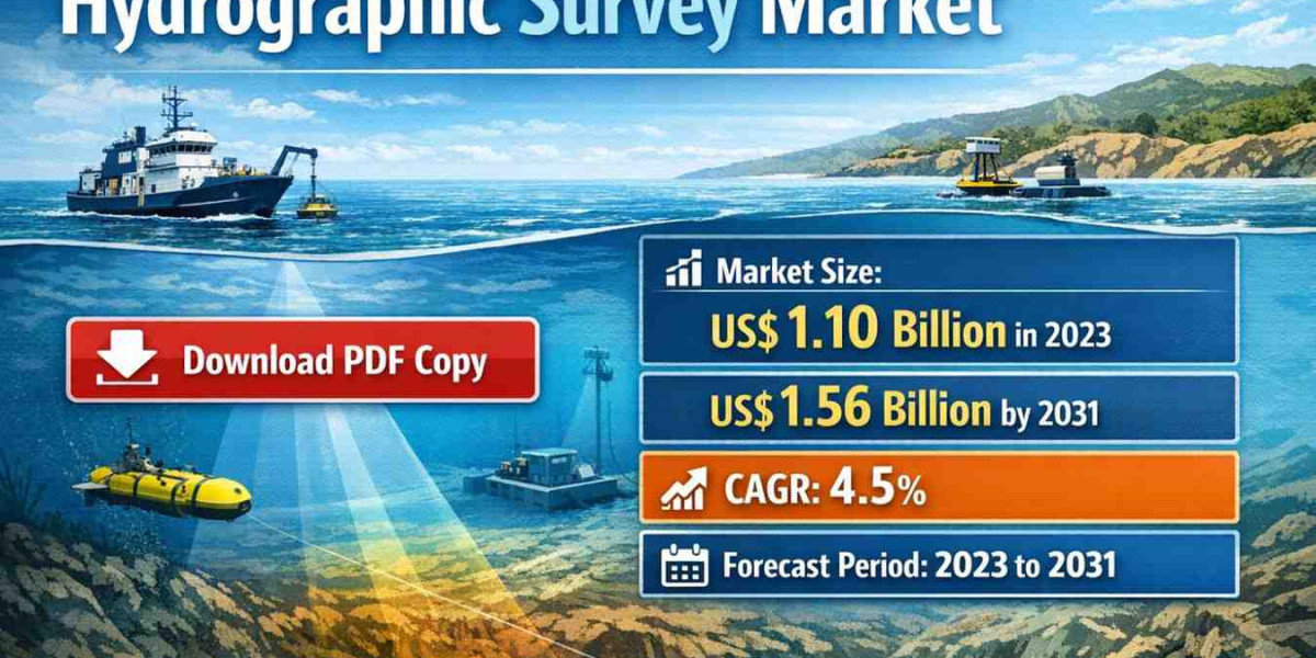
The global maritime landscape is undergoing a significant transformation driven by the expansion of offshore renewable energy, the necessity for modern maritime infrastructure, and the continuous evolution of subsea exploration technologies. The hydrographic survey market is at the forefront of this shift, providing the critical data required for safe navigation, coastal engineering, and resource management. As we look toward 2031, the industry is poised for substantial growth, fueled by technical innovations in autonomous systems and a rising demand for high resolution seafloor mapping.
Market Report Scope and Definition
A hydrographic survey market scope involves the measurement and description of the physical features of oceans, seas, coastal areas, lakes, and rivers. This specialized branch of applied sciences focuses on mapping the depth of the water column, identifying underwater hazards, and documenting the morphology of the seabed. The scope of this market report encompasses various dimensions, including survey techniques, equipment types, and end user applications.
The market is segmented by components, which include hardware such as sensing systems, positioning systems, and subbottom profilers, as well as sophisticated software solutions for data acquisition and post processing. In terms of platforms, the report analyzes the shift from traditional manned survey vessels to modern Unmanned Surface Vehicles (USVs) and Autonomous Underwater Vehicles (AUVs). These platforms serve a diverse range of sectors, including commercial maritime, defense, offshore oil and gas, and the rapidly growing offshore wind energy segment.
Market Dynamics and Growth Catalysts
The trajectory of the hydrographic survey market through 2031 is defined by several key drivers. Primarily, the global push for decarbonization has led to a massive increase in offshore wind farm installations. These projects require extensive hydrographic surveys during the site selection, construction, and maintenance phases. Without precise bathymetric data, the structural integrity of offshore assets and the safety of cable laying operations cannot be guaranteed.
Furthermore, the expansion of the Blue Economy is encouraging nations to invest heavily in their Exclusive Economic Zones (EEZs). Deep sea mining and the exploration of rare earth minerals on the ocean floor are emerging as significant long term drivers. As terrestrial resources become more difficult to extract, the maritime industry is turning its focus toward the deep ocean, necessitating advanced hydrographic tools that can operate at extreme depths and pressures.
Technological integration is another vital factor. The move toward Satellite Derived Bathymetry (SDB) and Light Detection and Ranging (LiDAR) technologies is allowing for faster data collection in shallow coastal waters. These methods complement traditional Multibeam Echo Sounder (MBES) surveys, providing a more comprehensive view of the marine environment.
Technological Evolution: Automation and AI
By 2031, the integration of Artificial Intelligence (AI) and Machine Learning (ML) into hydrographic software will be a standard industry practice. Currently, one of the primary bottlenecks in the surveying process is the time required for data cleaning and processing. AI algorithms are now being developed to automate the identification of outliers and noise in sonar data, significantly reducing the turnaround time from data collection to final chart production.
The rise of autonomous platforms is also reshaping the cost structure of the market. USVs and AUVs reduce the need for large, expensive mother ships and minimize the human risk associated with offshore operations. These autonomous systems can operate for extended periods, covering vast areas of the seafloor with high precision, which is particularly beneficial for environmental monitoring and pipeline inspections.
Download Sample PDF Report@ https://www.theinsightpartners.com/sample/TIPRE00019125
Regional Insights and Market Expansion
Geographically, the Asia Pacific region is expected to witness the highest growth rate during the forecast period. Rapid urbanization, increasing maritime trade, and significant investments in port infrastructure in countries like China, India, and Vietnam are driving this demand. Additionally, territorial disputes and the need for coastal surveillance are pushing defense departments in the region to upgrade their hydrographic capabilities.
North America and Europe remain mature markets, characterized by high adoption rates of cutting edge technology. In these regions, the focus is shifting toward sustainable coastal management and the decommissioning of legacy offshore oil and gas infrastructure, both of which require detailed hydrographic assessments.
Competitive Landscape and Top Players
The hydrographic survey market is characterized by a mix of established technology providers and specialized service firms. These organizations are focusing on strategic partnerships, mergers, and product innovations to maintain their market positions. Leading entities are increasingly offering integrated solutions that combine hardware, software, and cloud based data management.
Some of the top players operating in the global hydrographic survey market include:
- Kongsberg Gruppen ASA: A leader in high performance sonar and autonomous underwater vehicle technology.
- Teledyne Marine: A global provider of wide ranging subsea technology solutions, from sensors to complex imaging systems.
- Fugro: A premier service provider known for integrated geo intelligence and asset integrity solutions.
- Xylem Inc. (SonTek/YSI): Specializes in water monitoring and hydrographic instruments for environmental assessment.
- Trimble Inc.: Provides high precision positioning and GPS solutions essential for accurate hydrographic mapping.
- Oarsman (Sonardyne): Renowned for underwater acoustic positioning and communication technologies.
- Hexagon AB (Leica Geosystems): A major player in LiDAR and sensor software integration for maritime applications.
Future Outlook
The future of the hydrographic survey market is intrinsically linked to the digital twin movement. As we progress toward 2031, the industry will move beyond static maps toward dynamic, real time digital representations of the underwater environment. These digital twins will allow port authorities and offshore operators to simulate various scenarios, from sediment transport to the impact of rising sea levels, with unprecedented accuracy.
Moreover, the standardization of hydrographic data through the International Hydrographic Organization (IHO) S-100 universal hydrographic data model will facilitate better interoperability between different systems. This will enable more seamless data sharing across global maritime networks, enhancing safety and environmental protection.
The Insight Partners provides comprehensive syndicated and tailored market research services in the healthcare, technology, and industrial domains. Renowned for delivering strategic intelligence and practical insights, the firm empowers businesses to remain competitive in ever-evolving global markets.
• Email: sales@theinsightpartners.com
• Website: theinsightpartners.com
• Phone: +1-646-491-9876